Deskripsi
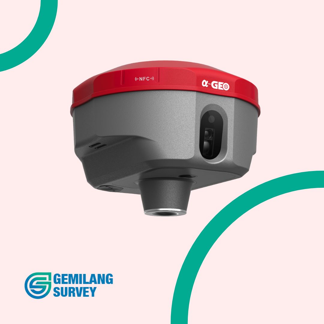
GPS Geodetik GNSS RTK Alpha Geo Matrix II adalah penerima GNSS RTK yang menggabungkan teknologi canggih untuk memberikan solusi survei yang efisien dan akurat. Alat ini dikenal karena fitur inovatifnya, termasuk kamera AR, laser, dan IMU, yang membuatnya menonjol di pasar.
Fitur Utama
- Akurasi Tinggi: Mendukung RTK dengan semua konstelasi GNSS utama, termasuk GPS, GLONASS, BeiDou, Galileo, dan QZSS, memberikan akurasi horizontal dan vertikal hingga tingkat sentimeter.
- Kamera AR (Augmented Reality): Memungkinkan visualisasi titik-titik pengukuran dalam lingkungan nyata, memudahkan proses stakeout dan verifikasi data.
- Laser: Digunakan untuk pengukuran jarak dan ketinggian dengan presisi tinggi, meningkatkan efisiensi pengukuran.
- IMU (Inertial Measurement Unit): Meningkatkan stabilitas sinyal GNSS dalam kondisi yang menantang, seperti di lingkungan perkotaan atau dengan vegetasi yang rapat.
- Desain Kokoh: Dilindungi dengan rating IP67, tahan air dan debu, serta tahan terhadap benturan dan getaran, cocok untuk penggunaan di berbagai kondisi lapangan.
- Fitur Lengkap: Dilengkapi dengan berbagai fitur seperti layar sentuh, penyimpanan internal, Wi-Fi, Bluetooth, dan opsi komunikasi seluler.
- Hemat Daya: Konsumsi daya efisien untuk masa pakai baterai yang lebih lama.
- Kompatibilitas Perangkat Lunak: Bekerja dengan berbagai perangkat lunak survei populer.
Spesifikasi Teknis GPS Geodetik GNSS RTK Alpha Geo Matrix II
PERFORMANCE
| Satellites | GPS: L1, C/A, L2C, L2P, L5
GLONASS: L1, L2 BEIDOU: B1, B2, B3, B1C, B2a, B26 GALILEO:The/E5a/E5b/E6 QZSS; L1/L2/L5/L6 SBAS: L1, L5 IRNSS: L5 |
| Channels | 1408 |
| Cold start | <60 s |
| Quick start | <15 s |
| Positioning output speed | 1 Hz – 20 Hz |
| Signal recapture | 3 s |
| RTK initialisation time | 10 s |
| Reliability of supply | 99,99% |
| Accuracy in time | 20 ns |
POSITIONING
| Differential solution | Horizontal 0.25 m + 1 ppm, Vertical 0.5 m + 1 ppm |
| Static accuracy | Horizontal 2.5 mm + 0.5 ppm, Vertical 5 mm + 0.5 ppm |
| RTK accuracy | Horizontal 8 mm + 0.5 ppm, Vertical 15 mm + 0.5 ppm |
PHYSICAL CHARACTERISTICS
| Material | Magnesium alloy |
| Size | 120 mm * 72 mm (+ 20 mm bottom mount) |
| Weight | 0,76 kg |
| Operating temperature | From -40 °C to 75 °C |
| Storage temperature | From -50 °C to 85 °C |
| Protection | IP67, protected against immersion for 30 minutes to a depth of 1m |
| Impact | Withstands falls from a height of 2 metres onto concrete |
| Vibration | MIL-STD-810G |
| Humidity | 100% Moisture resistance |
BATTERY
| Fast charging | Yes |
| Duration | 12 hours in rover mode, 7 hours in base mode, 15 hours in static mode |
| Type | Lithium-ion battery |
PHYSICAL COMMUNICATIONS
| Port LEMO | External radio communication |
| USB Type-C | Upload / Data transfer |
| SIM | Nano-SIM support |
| Antenna port | UHF-SIM interface |
WIRELESS COMMUNICATIONS
| Radio: Transmission power | 1-1.5 W, switchable |
| Radio: Frequency range | 410-470 MHz, with the ability to set frequency |
| Radio: Protocols | TrimTalk450s, South, Satel, PCC-EOT |
| 4G modem | Built-in 4G full-frequency multi-band full-frequency modem, supporting WCDMA/CDMA2000/TDDD-LTE/FDD-LTE |
| WIFI | 802.11b/g, access point and client mode |
| Bluetooth | Bluetooth V5.2 Classical / BLE Prorietary |
DATA FORMAT
| Differential data | RTCM 2.X, RTCM 3x, CMR and CMR+, SCMRX |
STORAGE
| Memory | 64 GB of internal storage, supports cyclic storage, with the ability to collect raw observations for 1 year based on a 5-second interval |
LASER
| High-precision range | 10 m |
| Accuracy (ambient temperature) | (3-5)mm + 1ppm |
CAMERAS
| Camera 1 (AR) | 5 Mpx HD camera with wide viewing angle and live lofting support |
| Camera 2 (Laser assistance) | 5 Mpx high definition camera with wide viewing angle for laser-assisted guidance |
OTHER CHARACTERISTICS
| Operating system | LINUX |
| Tilt compensation | IMU up to 120 |
| Compatible controllers | All Android devices |
DESIGN
| Button | 1 * Power button |
| Indicators | 1 * Power Indicator, 1 * Bluetooth Indicator, 1 * Data Indicator, 1 * Satellite Indicator |
| Voice | Intelligent voice prompts |
| Web interface | Compatibility with WEBUI configuration |
Aplikasi
- Survei topografi
- Batas tanah
- Konstruksi
- GIS
- Pertanian presisi
- Penggalian
- Drone mapping
- Arkeologi
- Penambangan

Ulasan
Belum ada ulasan.