Deskripsi
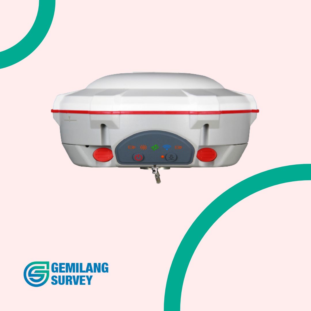
GPS Geodetik GNSS RTK Sinognss T300 adalah penerima GNSS RTK ringkas yang dirancang untuk memenuhi kebutuhan survei presisi. Alat ini menawarkan kombinasi akurasi, efisiensi, dan keandalan yang membuatnya populer di kalangan surveyor profesional.
Fitur Utama
- Akurasi Tinggi: Mendukung RTK dengan semua konstelasi GNSS yang berfungsi, memberikan akurasi horizontal dan vertikal hingga 10 mm.
- Pelacakan Multi-Konstelasi: Mendukung GPS, GLONASS, BeiDou, Galileo, dan QZSS untuk memastikan akuisisi sinyal yang optimal di berbagai lingkungan.
- Desain Kompak dan Ringan: Mudah dibawa dan digunakan di lapangan.
- Fitur Lengkap: Termasuk berbagai fitur seperti RTK Fix and Hold, tilt compensation, dan heading output.
- Hemat Daya: Konsumsi daya rendah untuk masa pakai baterai yang lebih lama.
- Kompatibilitas Perangkat Lunak: Bekerja dengan berbagai perangkat lunak survei populer.
Spesifikasi Teknis GNSS RTK Sinognss T300
- Jumlah Kanal: 220
- Akurasi:
- Horizontal: 10 mm RMS (RTK Fix)
- Vertikal: 15 mm RMS (RTK Fix)
- Teknologi Antena: Internal multi-band GNSS antenna
- Jangkauan RTK: Hingga 5 km (Base and Rover)
- Mode Operasi: RTK Static, RTK Kinematic, PPK
- Komunikasi: UHF, Bluetooth, Wi-Fi, 4G
- Baterai: Baterai internal isi ulang, 7.4V 5000mAh
- Waktu Operasi: Hingga 8 jam (penggunaan tipikal)
- Dimensi: 180 x 130 x 50 mm
- Berat: 800 g
| Signal Tracking | ||
| 572 channels for simultaneously tracking satellite signals | ||
| GPS BeiDou BeiDou Global Signal GLONASS Galileo QZSS SBAS |
L1, L2, L2C, L5 B1, B2, B3 B1C, B2a L1, L2 E1, E5a, E5b Reserved WAAS, EGNOS, MSAS, GAGAN |
|
| Performance Specifications | ||
| Cold start Warm start Hot start Initialization time Signal re-acquisition Initialization reliability |
<50 s <30 s <15 s <10 s <1.5 s >99.9% |
|
| Positioning Specifications | ||
| Static and Fast Static Long Observations Static Real Time Kinematic DGPS SBAS Standalone |
2.5 mm + 0.5 ppm Horizontal 5 mm + 0.5 ppm Vertical 3 mm + 0.1 ppm Horizontal 3.5 mm + 0.4 ppm Vertical 8 mm + 1 ppm Horizontal 15 mm + 1 ppm Vertical <0.4 m RMS 1 m 3D RMS 1.5m 3D RMS |
|
| Communications | ||
| 1 Serial port (7 pin Lemo) | Baud rates up to 921,600 bps | |
| UHF modem1 : Tx/Rx with full frequency range from 410-470 MHz2 Transmit power: 0.5-2 W adjustable Range: 1-5 km3 |
||
| 4G modem 4G Bands: 800/900/1800/2100/2600 MHz 3G Bands: 900/2100 MHz 2G Bands: 900/1800 MHz Support GSM, Point to Point/Points and NTRIP |
||
| Position data output rates: 1 Hz, 2 Hz, 5 Hz, 10 Hz, 20 Hz 5 LEDs (indicating Power, Satellite Tracking, GPRS Status and Differential Data) Bluetooth® : V 4.0 protocol, compatible with Windows OS and Android OS |
||
| Data Format | ||
| Correction data I/O Position data output |
RTCM SC104 Version 2.x, 3.x formats, CMR(GPS only),CMR+(GPS only) ASCII: NMEA-0183 GSV, RMC, HDT, VHD, GGA, GSA, ZDA, VTG, GST; PTNL, PJK; PTNL, AVR; PTNL, GGK ComNav Binary update to 20 Hz |
|
| Physical | ||
| Size(L × W × H) Weight |
15.8 cm × 7.5 cm 0.95 kg with two batteries |
|
| Environmental | ||
| Operating temperature Storage temperature Humidity Waterproof and dustproof Shock |
-40 °C to + 65 °C -40 °C to + 85 °C 100% non-condensing IP67,protected from temporary immersion to depth of 1 m Designed to Survive a 2 m drop onto concrete |
|
| Electrical and Memory | ||
| Input voltage Power consumption Li-ion battery capacity Memory |
5-27 VDC 3.1 W4 2 × 2000 mAh, up to 9 hours typically 8 GB |
|
| Software | ||
| Survey Master Android-based data collection software Carlson SurvCE field data collection software (optional) MicroSurvey FieldGenius field data collection software (optional) |
||
| 1.UHF Modem and 4G Modem is default configuration and it can be removed according to your specific needs. 2.Integrated UHF ranges from 410 to 470 MHz with 12.5 KHz channel spacing. 3.Working distance of internal UHF varies in different environments, the maximum distance is 5 Km in ideal situation. 4.Power consumption will increase if transmitting corrections via internal UHF. 5.8GB is the default internal memory and optional 16GB, 32GB is available to order. Please clarify when placing the order |
||
| Specifications subject to change without notice. |
Aplikasi
- Survei topografi
- Batas tanah
- Konstruksi
- GIS
- Pertanian presisi
- Penggalian
- Drone mapping


Ulasan
Belum ada ulasan.